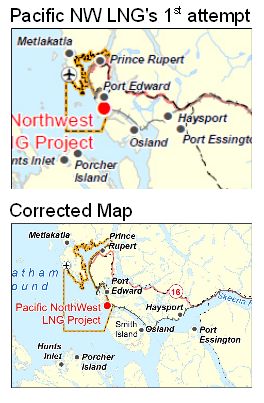
UPDATE August 22, 2013: We’re pleased to report a small victory in the case of the missing Skeena! The Canadian Environmental Assessment Agency has agreed to extend public comment and participant funding deadlines after West Coast Environmental Law and the T. Buck Suzuki Environmental Foundation drew attention to an inaccurate map – one that failed to show the Skeena River – used in public notices about the Pacific Northwest LNG project near Prince Rupert.
West Coast has received a letter from CEAA that states:
“[R]ecognizing the regrettable issue with the proponent’s map and the potential confusion that may result, the Agency will undertake the following corrective actions:
- Both the original map and the revised map are available on the Registry, along with a notice referring to the revision and the date on which it took place.
- The Agency will extend the applications under the Participant Funding Program funding until September 20, 2013.
- The Agency will also extend the comment period on the draft EIS Guidelines (dated April 8, 2013) until September 20, 2013.”
Public notice of these corrective actions may now be found on the CEAA website.
However, as West Coast’s Executive Director and Senior Counsel, Jessica Clogg notes in our release about CEAA’s response:
The ‘case of the missing Skeena’ may be resolved, but the broader question of whether the Canadian Environmental Assessment process will deliver for British Columbians remains outstanding. We need to move beyond a piece meal approach and ensure that we are taking a comprehensive, strategic look at the cumulative impacts of all of these proposed LNG projects on the things British Columbians value.
Remember when Enbridge accidentally left hundreds of islands off the maps it submitted in support of the  environmental assessment of its Pipelines and Tankers project? Well, it turns out that Enbridge is not the only cartographically-challenged oil and gas company. Take a look at the two maps on the right. The first is a close-up of a map originally submitted by Pacific Northwest LNG to the Canadian Environmental Assessment Agency to show the location of its proposed Liquefied Natural Gas (LNG) facility in Prince Rupert (click here for the full original version). The second is from the corrected version, submitted after environmental groups and local media noted that something was missing from the first map.
Do you see the difference?
That’s right: Pacific Northwest LNG forgot to include the nearby Skeena River on its original map. Now, the Skeena, BC’s second largest river, is far from an insignificant landmark, and the fact that someone wants to build an LNG plant nearby has huge ecological, cultural and economic implications for the river and those who depend on it. In particular, there are very real concerns that the LNG facility, located near important fish habitat that supports Skeena salmon runs, could have a very real impact on its fish and ecosystem.
Luanne Roth, Northcoast Energy Campaigner, T. Buck Suzuki Environmental Foundation, explains:
Flora Bank, just offshore of the proposed Pacific Northwest LNG site on Lelu Island, supports 50-60% of the eelgrass in the Skeena Estuary and is a critical part of the Skeena ecosystem. The Fisheries Service has called it "critical salmon habitat" and in 1975 this location was rejected for a similar project because of the potential impacts to the Skeena’s salmon runs.
It seems significant that the Environmental Impact Statement Guidelines prepared by Pacific Northwest LNG for the environmental assessment does not mention the Skeena.
CEAA complicity
Interestingly enough, this error isn’t “just” an embarrassment for the company. It may have impacted the fairness of the environmental assessment process itself. That’s because the Canadian Environmental Assessment Agency used the erroneous map in on-line public notices inviting the public to participate in the environmental assessment of the project.
Not that you could tell that now, since CEAA has removed the original map from all of the notices (without noting the substitution), and replaced it with the new, corrected map. See, for example, this notice (now using the corrected map), inviting the public to apply for participant funding – which, until early August, prominently displayed the Skeena-free map.
We’ve written to CEAA asking them to:
- Invite further public comment – and a further opportunity to apply for participant funding – from people who may have been confused by the inaccurate map; and
- Maintain copies of the historic notices (with the incorrect map), but add information indicating that the error was made and clearly indicating the correct information.
We’ll have to see whether CEAA takes responsibility for its error in using this map in its notices without checking its content.
By Andrew Gage, Staff Lawyer
Maps taken from CEAA website, originally provided by Stantec.